Someone was just comparing GPS and BIM and asked when was the last time you unfolded a paper map while driving, as a way to criticize those in AEC who, while having digital models, still make drawings.
But, would a model of the world alone, streamed to mobile devices have done the job?
Um, obviously no. We still have maps. The model of the world, or the world itself, is not enough. We still say
“I’m here and I want to go there.”
And a map is made and shown to us progressively and turn by turn.
BIM, for 25 years (or 35 for some), is pretty much stuck at the most idiotic of all possible places. Software companies have given us a model of our project, and then told us to generate old-school maps of them while some enthusiasts clang on like a grinding bottom bracket:
“the model is everything, no maps needed.”
Our situation is not anything like GPS/Maps, because the software developers in BIM are really dim. And the users are left LOST.
Borges saw it already in 1946:
… In that Empire, the Art of Cartography attained such Perfection that the map of a single Province occupied the entirety of a City, and the map of the Empire, the entirety of a Province. In time, those Unconscionable Maps no longer satisfied, and the Cartographers Guilds struck a Map of the Empire whose size was that of the Empire, and which coincided point for point with it. The following Generations, who were not so fond of the Study of Cartography as their Forebears had been, saw that that vast map was Useless, and not without some Pitilessness was it, that they delivered it up to the Inclemencies of Sun and Winters. In the Deserts of the West, still today, there are Tattered Ruins of that Map, inhabited by Animals and Beggars; in all the Land there is no other Relic of the Disciplines of Geography.
– Jorge Luis Borges: On_Exactitude_in_Science (1946)
I said BIM developers are dim though, didn’t I?
And you have to admit that’s true, don’t you?
What kind of developers, to use the GPS analogy, would put satellites in space for location tracking, build a digital model of the world, stream it on demand to mobile devices, AND OMIT TO INCLUDE ANY MAPS FUNCTIONALITY OTHER THAN PRINTING TRADITIONAL MAPS, AS IF ON PAPER?
That’s DIM.
DIM-WITTED.
REALLY EXTRAORDINARILY SO.
More of the story of Google Maps:
Google Maps launched February 8th 2005, almost 20 years ago. I remember using it then, a couple years before the first iPhone.
In 2005 we no longer needed those map books from gas stations, or those auto club (AAA) pre-order trip books you’d order weeks before your trip. They’d map your trip for you, and mail you back a book of relevant maps with door to door turn by turn directions just for you, just for your trip.
So in 2005, I can do that ‘myself’: I remember doing this. I tell Google, I’m here and want to go there, and … ta da!… I get a set of maps at a legible zoom, and turn by turn directions in a list on a page or 3 or 4 pages.
So I’d print that on paper, staple the paper stack, and take the printed maps and directions into the car, and if lucky I’m not driving alone, so a navigator could read those and call out the turns, in time!
Google Maps ran on a variant of the Mercator Projection (a flat map) but in any case the world model is detailed, more now but already in the beginning. A mobile version was released in 2006 but GPS integration didn’t come until November 2008. So a lot of people had 3 years to have fun printing google maps on stacks of papers.
In total it looks like for just short of 4 years, people were doing that, printing PDFs of maps or printing them on paper. Looking back you could call that 4 year period a rut. The tech was stuck in a rut for 4 years, which is not that long, really.
After that the tech evolved with maps streaming to your phone and GPS position powering real time turn by turn. No more PDFs and no more paper. The visualization / navigation / mapping experience was redesigned, integrated directly into the world map, and streamed to your device.
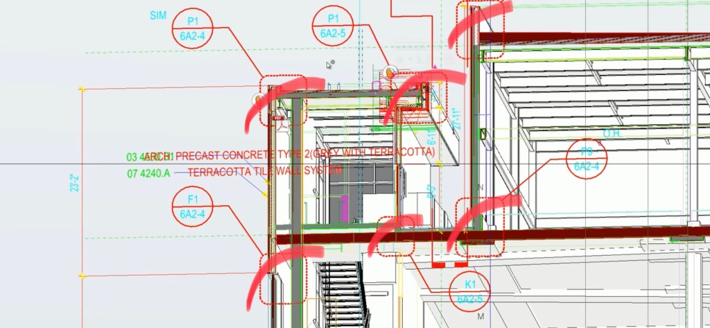
Look at us in the Architecture, Engineering, and Construction (AEC) industry. Our apps have their own equivalent of nav maps. They’re different but similar. They’re called technical drawings. They express things not about a whole project but about certain narrowed views within it. So they’re kind of like maps.
In AEC these have been stuck in a rut for over 30 years now. We’ve had elaborate digital models of our projects for 30 years and still today the only option given to us in these apps is to print traditional drawings as if on paper.
No imagination is applied to this at all. No development is done. No possibility recognized. No vision of what visual engagement with models could look like if it were integrated within models, like Google Maps did once it came out of its 4 year rut. It put the orienteering internalized within the map, not ONLY externalized for printing as if on paper (PDF) or, on paper.
A 30 years stasis in AEC software.
In a rut with no end in sight.
Our wheel’s in a ditch.
And we just sit there.
For 30 years.
And counting.
And these developers are not embarrassed.
They need to be.
It’s pathetic.
30+ years of stupefying counter-productivity. You have to eat that, software companies. It’s YOU. It WAS you. It still is YOU. You are the problem. You’ve made a mess of an entire industry.
You need to atone. You need to fix this.
Here’s how to get un-lost:
It’s worth reading and please do. It’s a living document. If you are a software developer or user and want to help edit this specification, message me:
Robert Snyder
Tangerine (project website)
OPEN VCS, equipment for visual close study, is an open source development project that combines technical drawing and digital modeling in fusion, with evolution in form that brings out the best of both media in a new expression greater than the sum of its parts.
OPEN VCS is intended as codebase ready for implementation in all digital modeling apps in the Architecture, Engineering, and Construction (AEC) industry.
Industry outcomes from models well equipped for visual close study (VCS) will surpass outcomes from models lacking VCS equipment. Traditionally, VCS equipment is externalized from digital models, as technical drawings in their traditional form.
OPEN VCS is the future of technical drawing.
There’s more to the Borges story
It recalls an earlier story from 1895:
The story elaborates on a concept in Lewis Carroll‘s Sylvie and Bruno Concluded: a fictional map that had “the scale of a mile to the mile.” One of Carroll’s characters notes some practical difficulties with this map and states that “we now use the country itself, as its own map, and I assure you it does nearly as well.”
– from Lewis Carroll, Sylvie and Bruno Concluded, Chapter XI, London, 1895
More on the Carroll story for those interested, here:
People are seeing the problem
Many saw it all along but were crowded out by clanging tech bro’s and hangers-on.
Les Gregory asks:
“Did we have more – or less – detailed understanding of the nuances of a design as a result, some might say, of a more intimate relationship between engineer, draughtsman and paper?”

That is the essential point. The quality of engagement with models (mental models) was very high when creating these drawings and it was difficult to fail to attain high quality interpretive engagement with the model (mental model) through conventional drafting.
Over the last 30 years as models have become digital (and mental of course because digital models mean nothing to anyone without adequate mental model formation) it’s become increasingly easy, and common, to fail to attain adequate model engagement. Drawing automation makes it easier to weakly engage. And not even realize it.
OPEN VCS is intended to raise again the level of model engagement through better equipment built into the digital models for Visual Close Study (VCS).
I did the original drawing-model fusion, at Bentley. Many have done similar development following that.
But the industry wants us all to move much farther than that.
Drawing is a lens for looking, at models mental, physical, and digital. That lens will evolve, because it’s fundamentally integral to creating and interpreting models.
OPEN VCS specifies and is coding open source what will establish for the next 500 years, the future form of expression of what for the last 500 years has been known as technical drawing.
More industry commentary:
Nicolas Gombault writes:
Did BIM lose its ways?
In their fight for relevance, BIM and its recent rebranding ‘Digital Twin’ seem to be racing toward more objects, more 3D detail, higher resolution survey, point clouds and photogrammetry meshes, more attributes, more data… and are being pushed to everyone, therefore, as the de-facto solution to access project information. After all: ‘it’s all there’.
We see people buying the best and latest software, paying for oversized storage and premium cloud compute, assembling it all into ‘the Digital Twin’, then spinning up big digital transformation programmes to train everyone – and indeed sometime simply interest them in – just having a look at the result.
Yet usually, it’s not more details that make a better Engineering Model (as in: ‘a simplified modelling of reality to analyse and predict’) but less. Just the right data, the right structure, the right behaviour modelled, will provide more insight, and allow better engineering & operating than a 5 TB point cloud or 1M photos.
Sure, your model may be 3D, or simulated in 3D, it can also be in GIS, a 2D cross section, a time chainage diagram, 10 lines of code, a register (yes you can use Excel) or a chart, just not a pie chart.
When was the last time someone asked a question about a dataset, and the answer was to give them the database telling them ‘It’s all there’? Yet that’s what our industry attempts to do by splashing BIM & Twins at anyone who dares ask a project question to a digital practitioner. B&T are relevant, as are databases, just not as the place where everyone must be nor the thing that everyone must know how to use.How about we try this instead:
In our next Digital Engineering Execution Plan, we plan how to manage ‘models’ to imagine, make, and live in enjoyable and sustainable spaces, efficiently… models to do Engineering; and how we will make this information accessible to everybody in a curated and digestible format that may very well not be, a BIM. My guess is such tools won’t need massive transformation programme to get adopted.
Enchanted by Meaninglessness
Sensible thoughts as those above are drowned out by armies of untethered-from-reality fantasists inspired somehow by the vaguest possible notions of future nirvanas of instantaneous understanding once all the data is there and the right goggles are worn over the eyes. And the right standards are followed. And so on.
I borrow an AI image from someone I know:
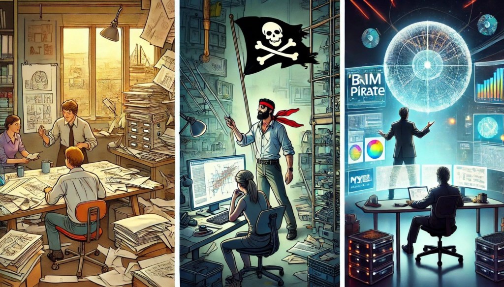
With some AI-generated image of some glorious future in mind, of being seated in a chair one-legged (never mind) staring at pie charts and screens while delivering one’s true self, evidently, to some kind of gleaming orb in space, the orb representing, I guess, effortlessness? Who knows what it’s supposed to mean; nobody cares; they just believe in it. Submission of mental effort itself (?), which will become unnecessary once digital something something is finally achieved and adhered to somehow, or something…
If that’s me, the pirate in the middle in the present time, I’m going back. To the left.
We should stop pretending that the thing on the right — which no one ever defines, and by which nevertheless so many are enchanted — means anything.
It doesn’t. It means nothing. Actually it does. The situation is worse than if it meant nothing. Because it actually does mean nothing. It’s nihilism. That’s what it means.
I’ll take the image on the left every single time. Serious people putting in the effort to work through complexity. To study with concentration and effort. To go very far beyond scratching the surface, and so, getting the job done and done right.
The other image is a mirage. It’s pulling your leg (off), and draining your mind, diverting it into counterproductive and ultimately useless tasks. It’s able to do this because you’re enchanted, by some belief, about why you would do that, because of some gleaming orb you submit yourself to in some kind of ecstatic future.
It’s a belief in nothing.
Accompanying Beliefs
I saw someone talking the other day about DATA ONTOLOGIES and Classifiable Relationships Between All Things, defined in a Classification Standard.
They said:
geometry is just one small part of it.
Geometry is just one small part? Of AEC?
A very wise man, truly, said:
“Without geometry, life is pointless.”
Just to sharpen a point that needs no sharpening, because well yeah, in general things are becoming pointless, increasingly so:
Without whatever ‘data’ is, digitalization is inhibited.
You know maybe that’s actually a good thing. In any case, better than pointlessness.
Think back 20 years ago.
Just a couple of years after, ok, maybe 5 years after delivering their 4th iteration of a line trimming tool, and having just started dipping their toes into AEC modeling and drawing automation, AEC software companies already 20 years ago trotted out their ‘forward looking’ slogans, like:
“BEYOND GEOMETRY”
And
“It’s the “I” in BIM”
And so on.
And looking back, prove me wrong please, these companies never had any idea what they were talking about. Or put it another way: they knew what they were talking about; it just had nothing to do with AEC, at all.
These companies never understood anything about the industries they supposedly served, what people actually do in those fields, the kinds of tools they need. Nothing.
They didn’t know what drawings are. They didn’t know what models are. And they don’t know what data is either.
But it doesn’t matter. It rolls on and on anyway.
Now we see the latest. We can take it as a kind of conclusion to the 20 years old “WE’RE MOVING BEYOND GEOMETRY!”
What’s there, in that beyond?
“Imagine the unlimited opportunities to define algorithms or or use prompt engineering to draw walls as an AI agent that learned wall assemblies from USG and then incorporated them into IFC in seconds.”
= someone on LinkedIn
If only I had a Time Machine, and, well, there is an abundant supply of those (used ones), in the future, and if only I could get to the future, get one, go back in time to the mid 90s when multi-line trim was the big feature released (the shaft tool came later, an X in a box), and tell some people the way it is… yeah 👍
You don’t know. And because you don’t know, you’re gonna make a real mess.
Too late now, isn’t it?
Or is it?
OPEN VCS is the GPS Maps analog of visual close study expression within AEC digital models
This is the third version of the OPEN VCS Specification. Please read it at this link:
OPEN VCS equipment for Visual Close Study in all digital models 26NOV2024x
The spec includes detailed description of the 8 core features of OPEN VCS, plus a dozen or so related features, among many other possible features beyond the proposed, shared, standardizable OPEN VCS feature set.
This is a living document. If you would like to comment or be invited to help edit the OPEN VCS specification, send me a message on LinkedIn: linkedin.com/in/robsnyder3333/
OPEN VCS: Equipment for Visual Close Study in (all) digital models
OPEN VCS is a triple fusion of:
- Digital modeling in any combination of model types and formats typical in AEC
- Technical Drawing in fusion within digital models, at true orientation in situ within the model, and with modern, model-based evolution in drawing’s form of expression.
- Cinematic camera rigging techniques inspired by the hundred years to date of the history of film.
“camera moves in film, combining informational control and emotional positioning; movement becomes the director’s editorial voice”
6 of the Best Shots of All Time (in Film)
“…everyone knows how to use the software but no one knows what to actually show on a drawing, people are so lost in the BIM model that they often forget (what they’re doing, what matters)…”
Adam Jackson, commenting under the article Why are Design Drawings Getting Worse? (Explained by AEC Professionals)
OPEN VCS IS FOR GETTING UN-LOST IN THE MODEL
To get a grasp on complexity.
To make things understandable.
To grapple with oceans of information.
To make things clear.
Remembering Peirce:
How to Make Our Ideas Clear
Charles S. Peirce
Popular Science Monthly 12 (January 1878), 286-302:
Click to access Peirce%201878%20Make%20Ideas%20Clear.pdf
© 2024 Robert Snyder and the OPEN VCS Collaborative
Robert Snyder
Tangerine (project website)
The Specification:
OPEN VCS equipment for Visual Close Study in all digital models 26NOV2024x